
Scholars in the digital humanities are pioneering new techniques for mapping and visualizing cultural information. Using geographic information systems, such as WorldMap, Google Fusion Tables, Neatline, and other techniques, these scholars are presenting complex data about cultural histories and cultural practices around the world. Three distinguished exponents, Peter Bol, Elijah Meeks, and Ruth Mostern, discuss the future of digital mapping for teaching and research in the humanities.
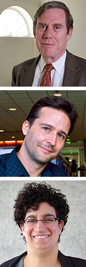
Peter K. Bol is the Charles H. Carswell Professor of East Asian Languages and Civilizations at Harvard, where his research is centered on the history of China’s cultural elites from the 7th to the 17th century. He led Harvard’s effort to establish support for geospatial analysis in teaching and research and in 2005 was named the first director of the Center for Geographic Analysis. He is currently directing two major projects: the China Historical Geographic Information Systems project, in which Harvard and Shanghai’s Fudan University are creating a GIS for 2000 years of Chinese history, and the China Biographical Database project, in which Harvard, Academia Sinica, and Peking University are collaborating on an online relational database of what is now 120,000 historical figures and which is being expanded to cover the Chinese political elite over the last 2000 years.
Elijah R. Meeks is a digital humanities specialist in scholarly digital media at Stanford University, with a focus on databases, spatial analysis, modeling, and representation of processes using abstraction and animation. Before joining Stanford, Meeks was a graduate student at the University of California, Merced, where he studied the connections between nature and society, as well as how to represent and analyze such knowledge using digital means. Alongside Ruth Mostern, he recently completed the Digital Gazetteer of the Song Dynasty, which uses MySQL and ArcGIS to visualize and analyze political change in medieval China. He is author of Son of the Great River (2009), a young adult novel set in the early Bronze Age.
Ruth Mostern is Associate Professor and member of the Founding Faculty at the University of California, Merced, where she is also director of the planning committee for the UC Merced Spatial Analysis and Research Center (SpARC). Before joining the UC Merced faculty in 2004, she was Head of Collection Development at the Electronic Cultural Atlas Initiative, a Berkeley-based international consortium that promotes the use of GIS and digital library technologies for communicating about culture and history. Her research focuses on historical geography, in particular, the relation between territory and state power in imperial China. She is also interested in developing methods to improve digital maps and timelines that support visualization and analysis in history and cultural heritage. A research-intensive undergraduate course on the history of the Silk Road, which she taught in Spring 2010, offers fascinating lessons about spatial history and the digital humanities as well as pedagogy.
Carswell Professor of Eastern Asian Languages Civilization
Director, Center for Geographic Analysis
Harvard University